PAOC Spotlights
Deep Waters Spiral Upward Around Antarctica
Since Captain James Cook’s discovery in the 1770s that water encompassed the Earth’s southern latitudes, oceanographers have been studying the physics of the world’s newest sea, the Southern Ocean, and how it interacts with the global circulation and the climate. Through observations and modeling, scientists have long known that large, deep currents in the Pacific, Atlantic and Indian Oceans flow southwards, converging on Antarctica. Here, they enter the Southern Ocean and overturn—bringing water up from the deeper ocean—before moving back northward at the surface. This completes the global circulation loop, which is important for oceanic uptake of carbon and heat, resupply of nutrients for use in biological production, as well as the understanding ice shelf melting. However, the 3D structure of the pathways that these water particles take to reach the Southern Ocean’s surface mixed layer and their associated timescales was poorly understood until recently.
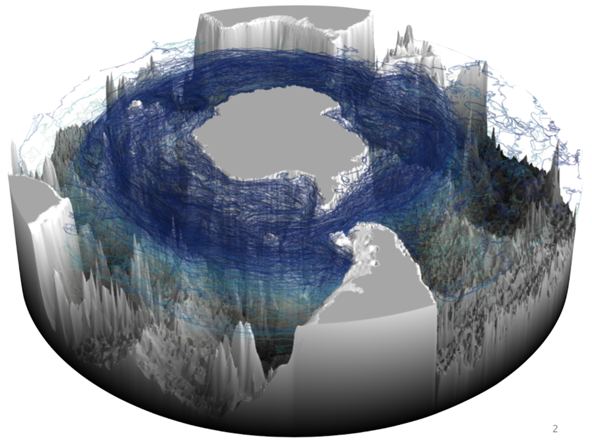
Now, researchers from MIT, Scripps, Princeton / GFDL, Los Alamos National Laboratory, University of Washington, and NASA JPL have found that deep, relatively-warm water from the three ocean basins enters the Southern Ocean and spirals southeastwards and upwards around Antarctica before reaching the ocean’s mixed layer, where it interacts with the atmosphere. The study published in Nature Communications also reveals that strong eddies, caused by topographical interactions at five locations within the current circling Antarctica, play a major role in this upwelling process. Additionally, the researchers were able to determine how much water from each ocean basin made it up this “spiral staircase,” and they think this journey happens much quicker than previous estimates suggest.
In the Southern Ocean, strong ocean-atmosphere interactions and eddies largely drive upwelling. Westerly winds encircling Antarctica blow cold, CO2-rich surface water northward from the continent across the Antarctic Circumpolar Current (ACC), the world’s strongest current and the only major current that circles the globe unimpeded by continents and flows around the northern edge of the Southern Ocean. Much of this cold water is from ice melt, caused by warmer, nutrient-rich waters entering the ACC at depth and gradually upwelling from the ocean’s interior below, about 1,000-3,000 meters deep.
Observations from the Southern Ocean tracers of ocean temperature and salinity provided clues to the structure of this overturning, but it wasn’t until recently that computer models were sophisticated enough to be able to run realistic simulations, allowing researchers to investigate if and how upwelling varies in three-dimensional space and what controls the upwelling structure.
To look at this, the researchers used three high-resolution, atmosphere-ocean coupled models, capable of resolving eddies, to follow virtual water particles from where they entered the Southern Ocean around 30 South and between 1,000 and 3,000 meters deep to where they crossed the mixed layer boundary, which was considered to be 200 meters deep. After being spun up, the climate model conditions were fairly consistent with those of the year 2000, which were then looped over itself and run for 200 years. “We tracked millions of these particles as they’re upwelling. Then we mapped out their pathways, and we can determine…and separate the volume transport— how much water is being moved—by these currents. So, we’re able to compare how important these different regional pathways are,” says co-author Henri Drake, a graduate student in MIT’s Department of Earth, Atmospheric and Planetary Sciences (EAPS), and member of the Program in Atmospheres, Oceans and Climate (PAOC). They also noted the time it took the particles to reach the mixed layer as well as locations of enhanced upwelling.
Their analysis revealed that the water parcels tended to flow southward primarily along western and eastern boundary currents in the Atlantic, Indian and Pacific Oceans, where they entered the ACC tracking with density surfaces. The Antarctic Circumpolar Current (ACC) and eddies around bathymetry also played an important role in the upwelling process. “In the deep ocean, water parcels follow density surfaces…which start really deep out where we release the particles and then get shallower as you go south,” says Drake. “So if you have a particle traveling south along the same density surface, it’s going to get higher in the water column, until eventually the density surface intersects with the mixed layer.” Additionally, five major topographic locations in the ACC – the Southwest Indian Ridge (SWIR), Kerguelen Plateau (KP), Macquarie Ridge (MR), Pacific–Antarctic Ridge (PAR), and Drake Passage (DP) – created areas of turbulence and high kinetic energy, which helped to upwell the majority of the water. “Eddies are basically these vortices in the Southern Ocean that are really important for transporting waters,” says Drake. “If you don’t have any eddies, the water would probably go around Antarctica and come back at the same latitude. But with eddies, when the particles are traveling in these streamlines, they’re going to get to a place of high eddy kinetic energy and surge south and up to the next streamline.”
They also found that half of the water that reached the mixed layer originated from the Atlantic Ocean, while the Indian and Pacific Oceans contributed a little over a fourth, each. The majority of these waters crossed this threshold after 28-81 years. In the highest resolution model, this timescale is about ten times faster than previous estimates produced by non-eddying models, which were closer to 150-250 years, demonstrating that upwelling rates could be critical for Antarctic ice melt with relation to future climate change, says Adele Morrison, a co-author and former postdoc at Princeton University. The models largely agreed, showing the robustness of the result. “Scientifically, this is significant, because for a long time we have thought of the upwelling as being primarily driven by the winds, which are pretty much uniform around the Southern Ocean,” says Morrison. “But here we have shown that the structure of the upwelling is really controlled by the under-sea topography and the eddy field.”
“It confirms that upwelling in the Southern Ocean is mediated by eddies, but it emphasizes how important eddies are and how localized some of the eddy activity is. So it makes it hard to represent in models that don’t have any eddies,” says John Marshall, the Cecil and Ida Green Professor of Oceanography in MIT’s Department of Earth, Atmospheric and Planetary Sciences, who was not part of the study. “I think the communication timescales might be a bit faster than we thought they were between the interior and the surface.”
The group plans to continue the work, investigating ocean-atmosphere interfaces, water particle trajectories and the propagation of climate change signals from deep water formation in the Northern Atlantic to the Southern Ocean. Drake adds, “Our description of the pathways that connect the deep ocean to the surface ocean open the door for future studies to connect the fluid mechanics of the deep ocean to exchanges of heat, carbon, and nutrients at the ocean-atmosphere interface that influence Earth’s climate.”
Learn more at Oceans@MIT.